


Topic 2c - Storm surges and coastal altimetry
A storm surge is an unexpectedly high water level brought on by high winds pushing water towards the coast and low atmospheric pressure causing sea level to rise.
In low-lying areas surges that occur on high tide may cause extensive flooding and destruction. Being among the most devastating of natural disasters, storm surges pose a huge threat to low lying coasts and river deltas around the world.
Surge modelling and forecasting
Altimetry measurements of sea surface height (SSH) can be used to validate numerical models used to estimate flood risk from cyclonic weather systems.
Scatterometers, altimeters and synthetic aperture radar (SAR) can also be used to measure wind speeds, both in the coastal zone and in the open ocean where no in-situ measurements are available.
The intensity of a storm is measured by monitoring sea surface temperature (SST).
Optional mini task:
Storm surges are often associated with hurricanes. Visit the US National Hurricane Center website on storm surges to see how models have been used to estimate inundation from storm surges for recent hurricanes. Under ‘Notable Surge Events’ you can view model runs. Which recent storm do you think caused the worst coastal inundation?
Featured Educators:
- Dr Paolo Cipollini
Explore the data
EUMETSAT Oceans MOOC Data Viewer
View featured satellites on the satellite tracking app
Don’t forget you can download the video and transcript with the links on the right.
Optional Further Reading
Imagery

Output from the National Weather Service SLOSH model indicating simulated water level heights from Hurricane Ike along the Texas and Louisiana coasts.
NOAA
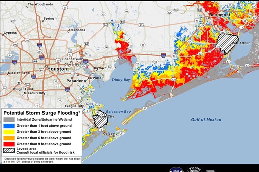
A potential storm surge inundation map near the Gulf of Mexico
NOAA